


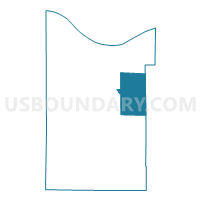
Voting District 0313420000001, Cheboygan County, Michigan
About
Outline

Summary
| Unique Area Identifier | 596222 |
| Name | Voting District 0313420000001 |
| County | Cheboygan County |
| State | Michigan |
| Area (square miles) | 57.91 |
| Land Area (square miles) | 48.78 |
| Water Area (square miles) | 9.12 |
| % of Land Area | 84.24 |
| % of Water Area | 15.76 |
| Latitude of the Internal Point | 45.52018140 |
| Longtitude of the Internal Point | -84.30034830 |
Maps


Graphs
Select a template below for downloading or customizing gragh for Voting District 0313420000001, Cheboygan County, Michigan


Neighbors
Neighoring Voting District (by Name) Neighboring Voting District on the Map
- Voting District 0310172000001, Cheboygan County, MI
- Voting District 0310742000001, Cheboygan County, MI
- Voting District 0318476000001, Cheboygan County, MI
- Voting District 1410640000001, Presque Isle County, MI
Top 10 Neighboring County Subdivision (by Population) Neighboring County Subdivision on the Map
- Benton township, Cheboygan County, MI (3,206)
- Aloha township, Cheboygan County, MI (949)
- Grant township, Cheboygan County, MI (846)
- Waverly township, Cheboygan County, MI (457)
- Bearinger township, Presque Isle County, MI (369)
Top 10 Neighboring Unified School District (by Population) Neighboring Unified School District on the Map
Top 10 Neighboring State Legislative District Lower Chamber (by Population) Neighboring State Legislative District Lower Chamber on the Map
Top 10 Neighboring State Legislative District Upper Chamber (by Population) Neighboring State Legislative District Upper Chamber on the Map
Top 10 Neighboring 111th Congressional District (by Population) Neighboring 111th Congressional District on the Map
Top 10 Neighboring Census Tract (by Population) Neighboring Census Tract on the Map
- Census Tract 9604, Cheboygan County, MI (3,629)
- Census Tract 9607, Cheboygan County, MI (3,358)
- Census Tract 9501, Presque Isle County, MI (1,971)